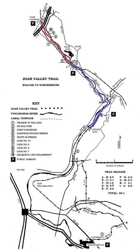
Here's the totally deceptively
easy looking route on the map.
Scott asked Mike to go scout out the route ahead of time. Thank god we did. Otherwise it would have been nothing short of a disaster. First mistake: tackling a ten-mile bike ride on the first ride of the season. Some of us have been playing soccer all winter and were therefore in good enough shape to tackle that long of a ride. Some of us, despite occasional yoga classes . . . weren't.
Second mistake: undertaking a ten-mile bike ride with some water and our bikes and not much else. We'd had a big lunch right before we left and though it would be an easy, flat ride and we'd be home long before dinner. We were wrong on all counts. We got to the camp not even sure that there was access to the trail we needed to be on. You could tell from a satellite image that it butted right up against the back of the property, and that there were some buildings nearby. The tree cover was way too dense to see if any trails or utility roads ran back there. Lucky for us, when we got to the camp (which was PACKED by the way. Apparently they were hosting a really cool engineering merit badge camping weekend in conjunction with Dam Days) we ran into the caretaker, who carefully quizzed us about our intentions. He gave us what must have seemed to him really comprehensive directions, but to us, having never been there, sounded a lot like Charlie Brown's teacher, interspersed with words like "switchback" and "might be underwater."
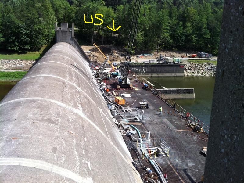
We headed off with gusto and hadn't gone a hundred yards before Mike, who was pulling Natey on the trail-a-bike, nearly wiped out going down a crazy steep hill* and had to get off and walk. Then we became convinced we were going the wrong way. Three of us stayed behind and Mike went down another trail to see if it was the right way. After 30 minutes of that type of nonsense, we finally realized we had gone the right way the first time around. We skidded down a small mountain (I've never been so jealous of Brendan's mountain bike) and finally hit what looked like it might be the trail we needed. Yay! We went another half mile or so and the trail split off in three directions, right at the Dover Dam, with no signage.
It's not actually us.
Just where we were standing, scratching our heads.
Well, two of us have advanced degrees, and all four of us are scouts of one flavor or another. We can handle this, right? One way dead-ended into the dam itself. That one was easy enough to eliminate! The second was headed vaguely west (based only on my estimate from the direction of the sun), which was kind of sort of the way we wanted to go. The third headed off in precisely the opposite direction. Mike left us there to go explore that one, because it looked like it could reasonably be described as either a "switchback" or a "lower train bed," or both. While he was gone, I got out my smartphone and tried to apply 21st century solutions to a 19th century trail. I discovered that we had maybe possibly gone the wrong direction when leaving the camp, but that if we followed the trail Mike was exploring, had a reasonably good chance of reaching the bridge we needed to cross to get over the river. The other route was pretty much out of the question because, if I was reading the map right, it was completely the wrong way. He came back and said he'd gone about a mile or so until he reached a tree across the trail, but saw no bridge. We decided to give it a shot anyway, mostly because there was absolutely no way at that point that we were dragging our bikes back up the mountain to where our car was parked.
We reached the tree where Mike had turned back before (which Nate felt compelled to touch 40 times while climbing over, despite the fact that it was covered in poison ivy), and kept going, on a path made out of rocks the size of small boulders, interspersed with mud flats that could cause at least four species of dinosaurs to go extinct in an afternoon. A little while later, noticing the sun starting to get low over the treetops, I started to get worried. But another mile or so down the trail, peeking through the trees was the bridge! I've never been so happy to see a hunk of ancient metal in my life.

We rested there for a few minutes, and then headed off on our way. Just a half mile later, we had to negotiate a section of State Route 800, with nothing between my children's heads and traffic whizzing by at 60 miles per hour except some plastic bike helmets we picked up at Target. Luckily, that was uneventful.
Just down the road, we got to yet another unmarked fork in the trail. One way looked like it could reasonably be a hike/bike trail. But, it could also have been someone's driveway for all we knew. And since we were in Tuscarawas County, there were better than even odds that the person living at the end of that driveway would be armed and not happy about four idiots trespassing on his property.
The other one looked like a regular road, but we really weren't sure. Mike checked out the second one, and decided the first one was the better bet. It was actually paved! And downhill! Life was awesome! Until . . . it wasn't. 100 yards down the trail were workers replacing a bridge that had washed out in a flood or a storm. Although the trail was technically closed, they took pity on us and let us walk our bikes down an 18-inch wide dirt path that ran along the unfinished bridge. From that point forward, the entire trail was made up of newly-placed limestone gravel only slightly larger than sand grains. Because it wasn't yet packed down, it was like trying to ride our bikes on the beach. There had also been horses on the path recently, and every hoofprint was like hitting a mogul on a ski slope.
I had forgotten my inhaler in the car, and quickly became winded with the exertion. Poor Mike, who was pulling an extra 100lb of combined weight between Natey and the trail-a-bike had to have been dying, but he soldiered on. We actually had to get off and walk our bikes for large portions of the trail, because there was just no pedaling through the quicksand. Around that point, my darling eldest son, whose fat mountain bike tires made it easier to ride in that garbage, sprinted ahead of us and well out of sight. After another few miles, not seeing any sign of him (and with the sun seriously starting to threaten sunset), I started to get anxious. But we ran into a guy walking his dogs who had seen him not long before who said he was a little way up the trail near a group of girls.
About seven miles in, we passed those girls, and then reached a fork in the trail, and when Brendan wasn't there waiting for us, my fretting turned into outright frantic doomsday scenarios running through my head. To make matters worse, I absolutely couldn't make it any further, so Mike left me and Nate at a parking lot nearby and raced ahead to try to find Brendan, get the car, and come back for us. Luckily I didn't have to wait long; he called within a half hour to tell me that he'd caught up with Brendan, nearly at the end of the trail, and that he was safe and sound. I wasn't sure whether to hug him to strangle him. Mike came back for us, we loaded up the bikes, and headed back for civilization, something like 4.5 hours after we left and just barely ahead of sunset.
All in all, Mike and Bren pedaled 10 miles, and Nate and I did about 7, give or take. The blue route on the map above is the section we all did together (including the small detour from the camp (#3 on the map) to the dam, and back. The red is the part that only Mike and Bren finished. I may never walk again.
* I'm really not exaggerating, for once. I looked up a topographical map of the area and we descended almost 300 feet in maybe a quarter mile.
Oh My! I'm glad you arrived back safe and sound. What an adventure!
ReplyDelete